Atmospheric river to continue to pound U.S. West
An atmospheric river has been pummeling northern and central California since the weekend, with wind, heavy rain and snow at high elevations. The locals call such storms a Pineapple Express, as it’s generated by low pressure in the area of Hawaii. These systems propel moist tropical air from Hawaii across the Pacific Ocean on what The Guardian called “blustery westerly winds.” The storm weakened significantly as it moved down the state, but the Los Angeles Times reported that the storm arrived there early Wednesday:
… after delivering a stronger-than-expected pounding to Northern California, breaking rainfall records, swelling rivers and triggering landslides.
And now another atmospheric river is expected to strike the U.S. West today, bringing heavy rain in addition to snow in the higher, mountain elevations. The National Weather Service (NWS) said in an advisory this morning (2:56 a.m. EST or 7:56 UTC):
The next storm system to enter the West Coast and eventually spread wintry weather elsewhere throughout the Lower 48 is forecast to move onshore later today. Initially, heavy coastal/lower elevation rain is expected across California with heavy snow likely into the Sierra Nevada, northern California ranges and southern Oregon. By Friday, the moderate-to-heavy snowfall located just north of an associated area of low pressure shifts into the northern Great Basin and northern Rockies. Total snowfall amounts over a foot (30 cm) are expected across the higher terrain, with multiple feet of heavy snow possible in the Sierra Nevada.
Forecasters are predicting generally minor impacts, such as increased traffic collisions. Thursday’s rainfall in Los Angeles County is expected to be relatively light, similar to the rain that fell Tuesday night and Wednesday morning.

What is an atmospheric river?
On average, 24 atmospheric rivers hit the U.S. West Coast each winter, from 1979 to 2019. But, in 2024, 51 atmospheric rivers hit the West Coast from October through March, which is more than the previous fall-through-spring period.
An atmospheric river is one of those key words or phrases we hear this time of year, especially related to the U.S. West coastal region. But what is it?
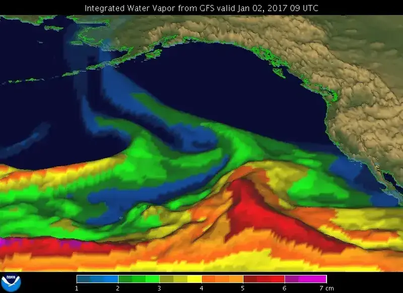
An atmospheric river is a narrow band of water vapor, which when it moves onto land, usually the West Coast of the United States, can bring heavy rain and snow in the high elevations, typically during winter. The National Oceanic and Atmospheric Administration (NOAA) says a typical atmospheric river has enough water vapor to be nearly equal to the typical flow of water at the mouth of the Mississippi River. The strongest atmospheric rivers can move 15 times that amount, and it is these events that cause the worst flooding.
Because atmospheric rivers are narrow “rivers” that can stay over one location for a long period of time, flooding due to heavy rain is a frequent concern, in addition to landslides. Landslides can wash out roads, cutting off normal travel in addition to damaging property and posing a threat to people’s lives.
While the strongest atmospheric rivers can pose a threat to life and property, most do not cause catastrophic damage and are a vital part of the water cycle, bringing much needed rain and snow to the Pacific Northwest as well as Northern California, and into the mountains. This snow can be beneficial to winter recreation in these areas, allowing ski resorts not to have to spend money on making or supplementing snow. The Pineapple Express, mentioned above, is one of the best-known atmospheric rivers. It originates near Hawaii, bringing the tropical moisture from that area to the West Coast of the United States.
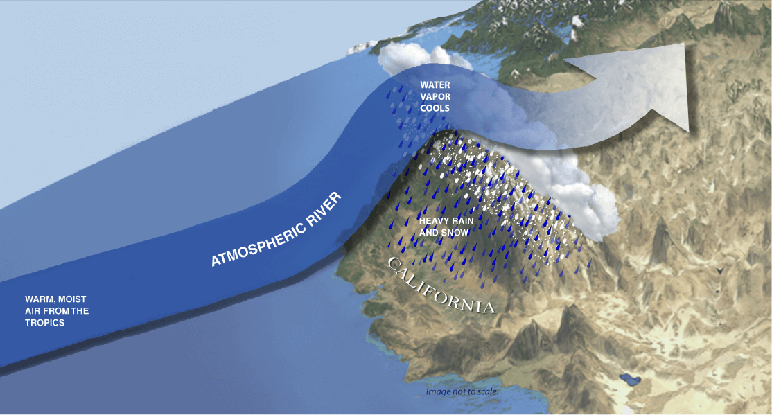
Image via NOAA.
Good and bad impacts
Atmospheric rivers have both positive and negative impacts on the environment. While they can add to a much-needed water supply and snowpack along the West Coast, they can also be destructive. This is why scientists study these phenomena. One way we’ve been able to learn more about them is through the use of hurricane hunter aircraft. Even when it’s not hurricane season, these flying laboratories are collecting data to use in weather models and research, so meteorologists can better understand and forecast atmospheric river events. The smaller, Gulfstream jets (which can fly at higher altitudes) collect these valuable data and send them back for more analysis.
In addition to planes, NOAA also utilizes weather satellites to monitor atmospheric rivers.

Bottom line: An atmospheric river has been pummeling California since the weekend, with wind, heavy rain and snow at high elevations. And another one is expected later today.
Sources:
NOAA: What are atmospheric rivers?
NOAA: What Is an Atmospheric River?
NOAA Hurricane Hunters
Read more: An uncommonly strong atmospheric river in Pacific Northwest
Read our previous article: Tigers in India see remarkable population recovery