I’m at a loss for words. These poor people in Mayotte had so little to begin with, and Cyclone Chido has left them with almost nothing. It’s now a race against time to find casualties/victims…#CycloneChido #Mayotte pic.twitter.com/BldcoVqIDx
— Volcaholic ? (@volcaholic1) December 16, 2024
Cyclone Chido devastated the French island of Mayotte, between Madagascar and Mozambique, on December 14, 2024, with wind speeds of more than 125 miles (200 km) per hour.
Devastation in Mayotte
The French island of Mayotte, normally sheltered from westward-moving cyclones thanks to the island of Madagascar, was hit full force by Cyclone Chido on December 14, 2024. Word has been slow in coming out, but officials fear that possibly hundreds could be dead after the 125-mile (200-km) per hour winds ripped roofs off homes and sent debris flying. Currently, most of the island is still without power, and communications towers are also down. Unfortunately, the damage included the island’s airport and sea ports, making it difficult for aid workers to access the island. The Guardian reported that Mayotte senator Salama Ramia told BFM-TV that:
There’s no water, no electricity. Hunger is starting to rise. It’s urgent that aid arrives, especially when you see children, babies, to whom we have nothing concrete to offer.
Satellite imagery shows the widespread destruction on the tiny 144 square-mile (373 square-km) island.
Meteo-France said that Mayotte hasn’t been hit by a cyclone of this strength in more than 90 years.
Mtsapéré, Mayotte. pic.twitter.com/kYZpVzy7yP
— Nahel Belgherze (@WxNB_) December 17, 2024
Kawéni, Mayotte pic.twitter.com/3VAszTKJho
— Nahel Belgherze (@WxNB_) December 17, 2024
Cyclone Chido destroyed a local university, as the images below show.
L’état de l’Université de #Mayotte. Tout est à reconstruire. pic.twitter.com/dhsT26KiQH
— Andriantsimbazovina (@Andriantsimbazo) December 17, 2024
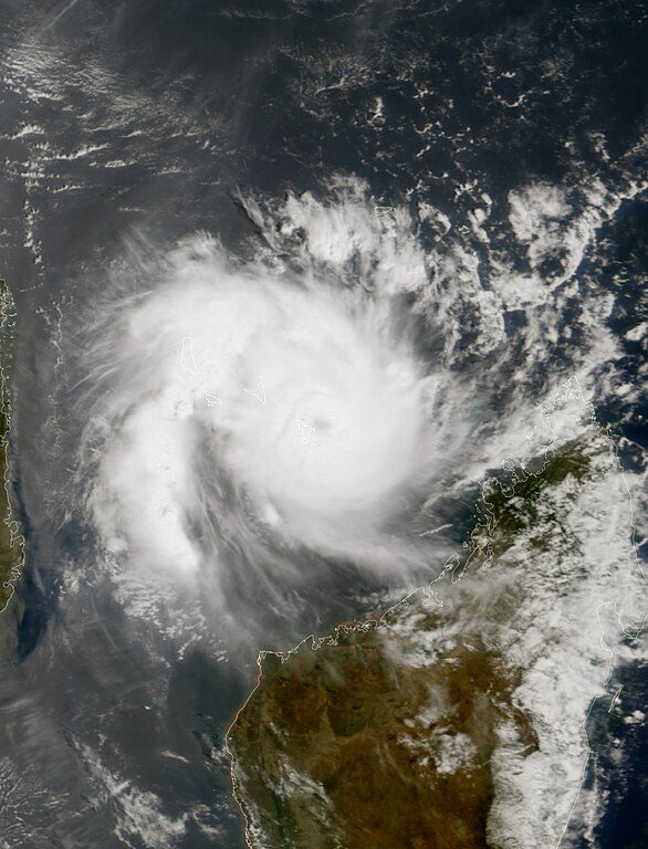
Here’s Chido approaching Mozambique on December 14
In a nighttime image captured on Dec. 14, 2024, by the #VIIRS Day-Night Band onboard the NOAA/NASA #SuomiNPP satellite, the lights from an offshore oil platform and a lightning strike are visible within the cloud bands of Tropical Cyclone #Chido as it approached Mozambique. pic.twitter.com/3v8Umc9o0D
— Joint Polar Satellite System (JPSS) (@JPSSProgram) December 17, 2024
Chido hit Africa’s mainland
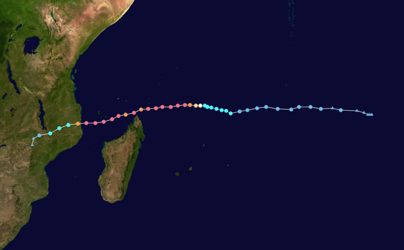
After Cyclone Chido left Mayotte, it hit Mozambique on Africa’s coast on December 15, 2024. Officials said at least 34 people died in Mozambique. From there, the storm moved on to Malawi and Zimbabwe, where it brought heavy rains.
UNICEF estimated that at least 90,000 children in Mozambique were impacted by Chido.
????????Hundreds to thousands of deaths,thousands of people lost their home: #Mayotte is totally devastated by #Chido with winds over 220km/h.In 36hrs the #tropicalcyclone of cat.4 has made 2 landfalls reaching #Mozambique.??14 and 15 December by #meteosat 12 #climateemergency pic.twitter.com/qUt1YCO4sY
— antonio vecoli ????#?? (@tonyveco) December 17, 2024
??Drone footage showed damaged houses and flattened vegetation when Cyclone Chido made landfall in Mozambique Sunday, killing at least 34 people, and destroyed classrooms in four schools.? pic.twitter.com/S3zv32YmMG
— VOA Africa (@VOAAfrica) December 17, 2024
The history of Cyclone Chido
Chido was the 3rd named tropical storm this season in the southwest Indian Ocean basin and intensified quickly. At first, the storm appeared to be headed toward Madagascar, but it passed just north of the large island. The cyclone then moved slightly southward as it passed right over Mayotte.

Cyclone strength
Meteo-France defines the strength of tropical cyclones in the southwest Indian Ocean using these classifications:
- A moderate tropical storm has max wind speeds from 63-87 kilometers per hour [39-54 mph] (at this point, the storm is strong enough to get a name).
- Severe tropical storm (wind speeds 88-117 kilometers per hour [55-72 mph]).
- Tropical cyclone (118-165 kilometers per hour [73-102 mph]).
- Intense tropical cyclone (166-212 kilometers per hour [103-131 mph]).
- Very intense tropical cyclone (wind speeds greater than 212 kilometers per hour [131 mph]).
Southern Hemisphere summer hasn’t peaked yet
While Chido is this season’s 3rd named storm, it is actually the 4th tropical system of the Southern Hemisphere’s 2024-25 tropical storm season. In fact, in August, a tropical depression formed but never became strong enough to get a name. The first named storm of the season wouldn’t come until more than a month later, September 29, when moderate tropical storm Ancha developed. Ancha would stay in the open ocean, not impacting land. Its strongest winds reached 52 miles per hour (83 kph) on October 2.
The second named storm, intense tropical cyclone Bheki, formed on November 8. At its strongest point on November 17, Bheki had maximum sustained winds of 120 miles per hour (194 kph). It dissipated on November 25.
The first three storms of the southwest Indian Ocean cyclone season (the unnamed tropical depression, Ancha and Bheki), developed before the official start of the season. The season runs from November 15 to April 30 with 80% of storms developing from December through March. Ocean water in the southwest Indian Ocean tends to be warmest during the first few months of the year. Therefore, there’s the potential for more tropical cyclone development as tropical cyclones get their strength from warm ocean water.
More cyclones to come after Chido?
Note that the cyclone season for the southwest Indian Ocean is just beginning. The warmest part of the summer in the Southern Hemisphere has yet to occur. But once it does, it’ll normally take a few weeks to a month for the ocean water to be at its warmest. Warm ocean water is fuel for tropical cyclones.
There are 23 names left to go on the list for cyclone season in the southwest Indian Ocean. With Ancha, Bheki and Chido already crossed off less than a month into the season, we may be monitoring this area for a while.
Bottom line: Cyclone Chido devastated the French island of Mayotte on December 14, 2024, before hitting Mozambique in Africa. See images here.
Via:
WMO Severe Weather Information Center
WMO Classification of Tropical Cyclones
Read more: 2024 Atlantic hurricane list of names
Read our previous article: The Sky This Week from December 20 to 27: Welcome the winter solstice
