There’s a mysterious island that appears and disappears like magic, just like Schrödinger’s Cat. This Schrödinger’s Island exists and doesn’t exist at the same time. Officially, it’s called Sandy Island, and it once appeared in maps, but it was never there in real life. Australian scientists decided to solve the mystery once and for all by embarking on an adventure to find this elusive archipelago.
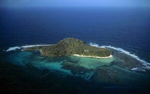
But when they reached the coordinates, all they found was endless blue waves. It’s like the island was playing a game of hide and seek with them. This story goes back to 1876. A whaling ship was crossing the area and reported an island. Whoever saw it said it was over 15 miles long north to south and around 3 miles wide, about the size of Manhattan, so not so tiny at all.
But every time researchers went to visit the area, they found nothing. So in 1974, an official mission from New Caledonia declared that Sandy Island was simply not a thing and excluded it from all maps. People went on with their lives until they noticed that the island was appearing on Google Earth as a black blob.
In 2012, another Australian expedition went out to check out the area to get some explanations. They had to write a eulogy for the long-lost island and explain what could have created this mess. For starters, mapping technology wasn’t at its peak back in the 1900s. It was easy to get the coordinates wrong.
Then there was the fact that the area is big on volcanic activities. It’s likely that volcanic lava cooled down and created a raft of some kind. Let’s say that the whaling ship went by, saw the volcanic raft, and thought it was land from a distance. But, hey, it’s just a guess.
Mount Lico: A Hidden Gem
Humans have ventured far and wide across the globe, and it may have seemed at some point that we discovered each and every nook of our planet. But when Mount Lico popped up on Google Earth, scientists were overcome with excitement. This hidden gem in northern Mozambique is no ordinary rainforest. It’s nestled inside a volcano.
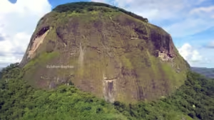
Determined to confirm the existence of this mysterious forest, experts assembled a team of top-notch scientists and specialists from around the world. The journey to Mount Lico was no walk in the park, with a daunting vertical rock climb standing between them and the forest. But after six years of planning and preparation, they were ready for the challenge.
Once they got there, they saw it was even better than they imagined. The place was like a perfectly tended garden. The forest sounded unique and different from other rainforests. There were some insanely huge caterpillars that looked dangerous. And they even found ancient pots and evidence of an untouched human ecosystem.
Terra Incognita: The Unknown Land of Antarctica
Ooh. Terra incognita means unknown land, and one of the largest unknown territories being uncovered today is the land beneath Antarctica’s ice sheets. Below the snowy surface, there is an entirely new world of canyons, waterways, and lakes, which are now being mapped. One can’t help but wonder, is there really liquid water below Antarctica’s frozen surface? Yep.
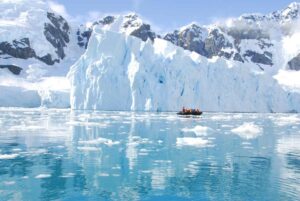
Water can exist without freezing due to pressure. The liquid water is the result of Earth’s warm interior, and that’s how we get things such as Lake Vostok. Now you can’t see it, but Lake Vostok is right here. Located in East Antarctica, it lies beneath 2.5 miles of thick ice. This huge lake is about 4,800 square miles. Humans could only discover it with the help of some top-notch technologies like seismic soundings and ice-penetrating radars.
According to these scientists, it’s likely that the lake has been there for up to 15 million years.
The Sacred Gangkhar Puensum
Bhutan is on the map for, among other things, being the happiest country in all of Asia. But it kept a hidden gem for all these years. One of the world’s tallest unclimbed mountains, Gangkhar Puensum. Bhutan is enmeshed in the glorious Himalayan mountains. That’s why the climbing community was beyond excited when they discovered an untouched mountain.
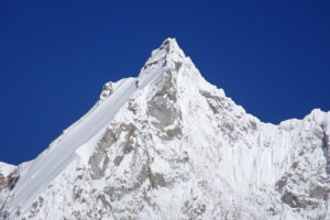
Imagine being the first person to climb an unexplored peak. That would probably guarantee you a spot in the Guinness World Records for sure. The mountain has been untouched because of a Bhutanese law. For locals, the mountain peak is a sacred site, shrouded in mystery and legends.
One of their beliefs is that the sacredness of climbing a mountain lies not in reaching its peak, but in truly communing with the mountain and enjoying the process. We got to admit, that is a bit of a newsflash for Westerners.
The Myth of Agloe
If you’re ever in the state of New York, make sure you check out the Agloe General Store. You’ll have to drive somewhere around the Catskills to find a beautiful, grand, big nothing. Agloe is one of America’s most famous paper towns, aka a fake town.

But this case is different from Sandy Island. Aglotown never existed, and it wasn’t a mistake. You see, there’s an old copyright practice among map makers. They add in paper towns so they can know when someone is simply copy-pasting their work. What they didn’t expect is that this would get completely out of hand.
Some say that one day, a guy picked up a map at a gas station that had Aglotown marked in it. The person decided to open a store over there and named it Agloe General Store. Some say the guy who opened the store faced a lawsuit from the mapmakers. Anyway, it only lasted enough years to become a national joke.
Americans drove from all over the US to get a picture of the town’s fake welcome sign.
The Mystery of Bermeja Island
And then we’ve got Bermeja Island, located in the Gulf of Mexico. This funky island appeared on many maps of the 16th and 17th centuries. It was probably drawn by Spanish explorers. Sure, the exact location varied from map to map, and its name sometimes appeared as Vermeja, but its existence was certain enough.

The Bermeja Island was last seen in a 1921 Mexican map, and then, poof, it dropped out of the horizon altogether. People started talking and wondering, did the island sink? Was it destroyed? In 2009, three official investigations happened to search for the island. They used high-tech technologies to scour the Mexican seabed, but Bermeja was nowhere.
Researchers had multiple guesses on what it could be. Let’s delve on one of these ideas. The idea was probably made up by old-day explorers to mislead their enemies in search of land and gold. Well, that seems plausible.
The Slums of Rio de Janeiro
Now let’s take a look at Rio de Janeiro. Once, the city was filled with informal territories. These places are known as slums or favelas. They’re like mini cities inside the big city. Some favelas are known to be underprivileged territories, where dwellers don’t get the same urban perks as other citizens, such as the sewage system and garbage pickups.
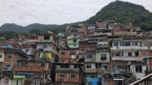
These slums grew so quickly that the government didn’t have time to keep track of their developments. So today, it’s usually the dwellers themselves that name the streets and make do with whatever they have at their disposal. One of the biggest slums in Brazil is located in Rio de Janeiro. The so-called Rocinha, and it was only recognized as a neighborhood by the local government in the 1990s.
The Depths of Our Oceans
Our own ocean floor is less mapped than Venus, Mars, and the Moon. In fact, 95 percent of our oceans are unexplored. Strange right? We do have the available technology, which is mainly sonar soundings, sending wave sounds to the ocean bed and registering what they hear back.

One of the main advantages of mapping the seabed more thoroughly would be to get more insight into marine hazards such as earthquakes, tsunamis, and volcanic eruptions. Plus, there are so many unidentified marine life. This could give us a great insight into preservation and discovering the true dynamics of our marine ecosystems.
That’s it for today! So hey, if you pacified your curiosity, Explore more Amazing Facts and stay on the mudassirmirza.online!
- The Science Behind Feeling Like You’re Being Watched
- The Full Story of Unicorns: Yes, They Were Real
Read our previous article: The Science Behind Feeling Like You’re Being Watched